


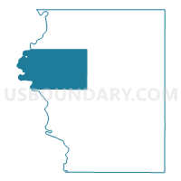
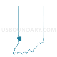
TURMAN, Sullivan County, Indiana
About
Outline

Summary
| Unique Area Identifier | 580695 |
| Name | TURMAN |
| County | Sullivan County |
| State | Indiana |
| Area (square miles) | 57.48 |
| Land Area (square miles) | 56.80 |
| Water Area (square miles) | 0.68 |
| % of Land Area | 98.82 |
| % of Water Area | 1.18 |
| Latitude of the Internal Point | 39.14371130 |
| Longtitude of the Internal Point | -87.54191890 |
Maps

Graphs
Select a template below for downloading or customizing gragh for TURMAN, Sullivan County, Indiana


Neighbors
Neighoring Voting District (by Name) Neighboring Voting District on the Map
- CURRY 3, Sullivan County, IN
- FAIRBANKS, Sullivan County, IN
- GILL 1, Sullivan County, IN
- GILL 2, Sullivan County, IN
- HAMILTON 5, Sullivan County, IN
- HAMILTON 6, Sullivan County, IN
- HUTSONVILLE 1 Voting District, Crawford County, IL
- HUTSONVILLE 2 Voting District, Crawford County, IL
- YORK Voting District, Clark County, IL
Top 10 Neighboring County Subdivision (by Population) Neighboring County Subdivision on the Map
- Hamilton township, Sullivan County, IN (6,869)
- Curry township, Sullivan County, IN (3,559)
- Hutsonville township, Crawford County, IL (1,177)
- Turman township, Sullivan County, IN (1,061)
- Gill township, Sullivan County, IN (871)
- Fairbanks township, Sullivan County, IN (733)
- York township, Clark County, IL (551)
Top 10 Neighboring Unified School District (by Population) Neighboring Unified School District on the Map
- Southwest School Corporation, IN (12,788)
- Northeast School Corporation, IN (8,687)
- Hutsonville Community Unit School District 1, IL (2,235)
Top 10 Neighboring State Legislative District Lower Chamber (by Population) Neighboring State Legislative District Lower Chamber on the Map
Top 10 Neighboring State Legislative District Upper Chamber (by Population) Neighboring State Legislative District Upper Chamber on the Map
Top 10 Neighboring 111th Congressional District (by Population) Neighboring 111th Congressional District on the Map
Top 10 Neighboring Census Tract (by Population) Neighboring Census Tract on the Map
- Census Tract 601, Clark County, IL (4,834)
- Census Tract 502, Sullivan County, IN (2,978)
- Census Tract 8801, Crawford County, IL (2,871)
Top 10 Neighboring 5-Digit ZIP Code Tabulation Area (by Population) Neighboring 5-Digit ZIP Code Tabulation Area on the Map
- 47882, IN (8,430)
- 47879, IN (3,302)
- 62451, IL (2,156)
- 62433, IL (998)
- 62477, IL (946)
- 47861, IN (616)
- 47849, IN (496)